
Cantón San Mateo topographic map
Interactive map
Click on the map to display elevation.
Cantón San Mateo
San Mateo has an area of 125.9 km² and a mean elevation of 311 metres.
About this map
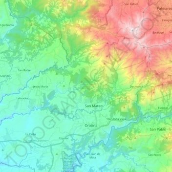
Name: Cantón San Mateo topographic map, elevation, terrain.
Location: Cantón San Mateo, Alajuela Province, Costa Rica (9.90631 -84.66835 10.01480 -84.45222)
Average elevation: 446 m
Minimum elevation: 19 m
Maximum elevation: 1,520 m
Other topographic maps
Click on a map to view its topography, its elevation and its terrain.
Valle Azul
Costa Rica > Alajuela Province > Cantón de San Ramón > San Lorenzo
Average elevation: 226 m
La Catarata
Costa Rica > Alajuela Province > Cantón de San Carlos > La Fortuna
Average elevation: 398 m