
Butte County topographic map
Interactive map
Click on the map to display elevation.
About this map
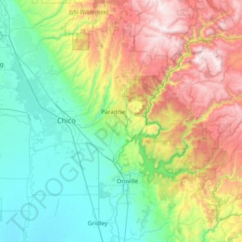
Name: Butte County topographic map, elevation, terrain.
Location: Butte County, California, United States (39.29576 -122.06926 40.15172 -121.07659)
Average elevation: 608 m
Minimum elevation: 15 m
Maximum elevation: 2,184 m
Other topographic maps
Click on a map to view its topography, its elevation and its terrain.
Chico
United States > California > Butte County > Chico
Chico, Butte County, California, United States
Average elevation: 93 m