
Volos Municipality topographic map
Interactive map
Click on the map to display elevation.
About this map
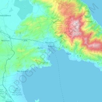
Name: Volos Municipality topographic map, elevation, terrain.
Average elevation: 228 m
Minimum elevation: -3 m
Maximum elevation: 1,604 m
Other topographic maps
Click on a map to view its topography, its elevation and its terrain.
Ελίτσα
Greece > Thessaly and Central Greece > Regional Unit of Magnesia > Municipal Unit of Zagora > Πουρί
Ελίτσα, Πουρί, Municipal Unit of Zagora, Zagora - Mouresi Municipality, Regional Unit of Magnesia, Thessaly, Thessaly and Central Greece, 370 01, Greece
Average elevation: 183 m