
Salur topographic map
Interactive map
Click on the map to display elevation.
About this map
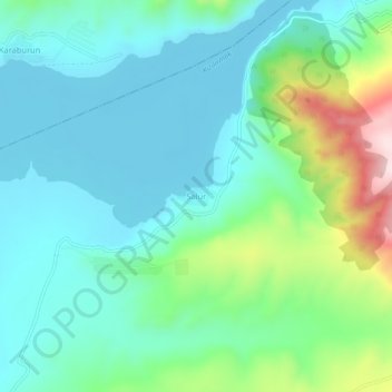
Name: Salur topographic map, elevation, terrain.
Location: Salur, Çorum Merkez, Çorum, Black Sea Region, Türkiye (40.60909 34.61291 40.64909 34.65291)
Average elevation: 599 m
Minimum elevation: 501 m
Maximum elevation: 918 m
Salur is on the banks of River Vegavathi at 18°32′00″N 83°13′00″E / 18.5333°N 83.2167°E / 18.5333; 83.2167. It has an average elevation of 118 metres (387 ft). It is bounded by Makkuva, Bobbili, Ramabhadrapuram and Pachipenta mandals of Andhra Pradesh state. Salur is surrounded with green forests and chains of hills on two sides and by River Vegavathi on the other two.