
Provincia Nor Lípez topographic map
Interactive map
Click on the map to display elevation.
About this map
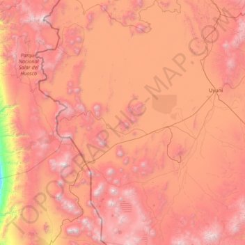
Name: Provincia Nor Lípez topographic map, elevation, terrain.
Location: Provincia Nor Lípez, Potosí, Bolivia (-22.02808 -68.55568 -19.54674 -66.28734)
Average elevation: 3,912 m
Minimum elevation: 1,737 m
Maximum elevation: 6,123 m
Other topographic maps
Click on a map to view its topography, its elevation and its terrain.
Morning Sun
Bolivia > Potosí > Provincia Sur Lípez > Municipio San Pablo de Lipez
Sol de Mañana is an area with geothermal manifestations in southern Bolivia, including fumaroles, hot springs and mud pools. It lies at about 4,900 metres (16,100 ft) elevation, south of Laguna Colorada and east of El Tatio geothermal field. The field is located within the Eduardo Avaroa Andean Fauna National…
Average elevation: 4,894 m
Santiago de Agencha
Bolivia > Potosí > Provincia Nor Lípez > Municipio Colcha K
Average elevation: 3,792 m
San Pedro de Quemes
Bolivia > Potosí > Provincia Nor Lípez > Municipio San Pedro de Quemes
Average elevation: 3,710 m
Huayajara
Bolivia > Potosí > Provincia Sur Lípez > Municipio San Pablo de Lipez
Average elevation: 4,370 m