
Ponta Grossa topographic map
Interactive map
Click on the map to display elevation.
About this map
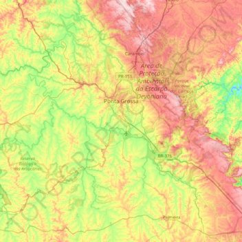
Name: Ponta Grossa topographic map, elevation, terrain.
Average elevation: 893 m
Minimum elevation: 664 m
Maximum elevation: 1,215 m
Ponta Grossa was founded on the farm of Miguel da Rocha Ferreira Carvalhaes who chose it as favorable agricultural land. The farm still exists towards Castro. In 1871 the city came to be called Pitangui, but the following year it resumed its original name. Sometimes it is the target of malicious humor due to what its name can send like in Portuguese. One way or another describes the characteristics of the vegetation and the regional topography.
Other topographic maps
Click on a map to view its topography, its elevation and its terrain.
Guarapuava
Guarapuava, Região Geográfica Imediata de Guarapuava, Região Geográfica Intermediária de Guarapuava, Paraná, South Region, Brazil
Average elevation: 1,001 m
Bom Sucesso
Bom Sucesso, Região Geográfica Imediata de Apucarana, Região Geográfica Intermediária de Londrina, Paraná, South Region, Brazil
Average elevation: 510 m
Colombo
Brazil > Paraná > Região Metropolitana de Curitiba > Colombo
Colombo, Região Geográfica Imediata de Curitiba, Região Metropolitana de Curitiba, Região Geográfica Intermediária de Curitiba, Paraná, South Region, Brazil
Average elevation: 958 m
Santa Quitéria
Santa Quitéria, Curitiba, Região Geográfica Imediata de Curitiba, Região Metropolitana de Curitiba, Região Geográfica Intermediária de Curitiba, Paraná, South Region, Brazil
Average elevation: 912 m
Cerro Azul
Brazil > Paraná > Cerro Azul
Cerro Azul, Microrregião de Cerro Azul, RMC, Mesorregião Metropolitana de Curitiba, Paraná, South Region, Brazil
Average elevation: 668 m
Iguazu River
Brazil > Paraná > Capitão Leônidas Marques
Iguazu River, Capitão Leônidas Marques, Microrregião Cascavel, Mesorregião Oeste Paranaense, Paraná, South Region, Brazil
Average elevation: 308 m