
City of Yonkers topographic map
Interactive map
Click on the map to display elevation.
About this map
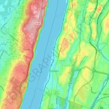
Name: City of Yonkers topographic map, elevation, terrain.
Location: City of Yonkers, Westchester County, New York, United States (40.90045 -73.91835 40.98834 -73.81042)
Average elevation: 58 m
Minimum elevation: 0 m
Maximum elevation: 172 m
Other topographic maps
Click on a map to view its topography, its elevation and its terrain.
Quarry Heights
United States > New York > Westchester County > Town/Village of Harrison
Quarry Heights, Town/Village of Harrison, Westchester County, New York, 10604, United States
Average elevation: 112 m
West Mount Vernon
United States > New York > Westchester County > Mount Vernon > West Mount Vernon
West Mount Vernon, Mount Vernon, Westchester County, New York, 10550, United States
Average elevation: 49 m
Mount Vernon
United States > New York > Westchester County > Mount Vernon
Mount Vernon, Westchester County, New York, United States
Average elevation: 41 m