
Make a donation
Idlib Governorate topographic map
Click on the map to display elevation.
Make a donation
About this map
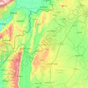
Name: Idlib Governorate topographic map, elevation, terrain.
Location: Idlib Governorate, Syria (35.37675 36.14861 36.34289 37.21628)
Average elevation: 400 m
Minimum elevation: 0 m
Maximum elevation: 1,771 m
Make a donation
Other topographic maps
Click on a map to view its topography, its elevation and its terrain.
Make a donation
Make a donation
A`zaz
During the Crusader era, Azaz, which was referred to in Crusader sources as "Hazart", became of particular strategic significance due to its topography and location, overlooking the surrounding region. In the hands of the Muslims, Azaz stymied communications between the Crusader states of Edessa and Antioch,…
Average elevation: 559 m
Make a donation
Make a donation
Al-Zabadani
Syria > Rif Dimashq Governorate > Al-Zabadani
Al-Zabadani or Az-Zabadani (Arabic: الزبداني, romanized: az-Zabadānī) is a city and popular hill station in southwestern Syria in the Rif Dimashq Governorate, close to the border with Lebanon. It is located in the center of a green valley surrounded by high mountains at an elevation of around 1,100 m.
Average elevation: 1,429 m
Make a donation
Make a donation