
Yancheng City topographic map
Interactive map
Click on the map to display elevation.
About this map
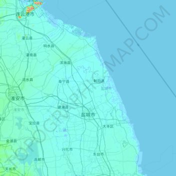
Name: Yancheng City topographic map, elevation, terrain.
Location: Yancheng City, Jiangsu, 224043, China (32.57560 119.45394 34.53214 121.64611)
Average elevation: 3 m
Minimum elevation: -4 m
Maximum elevation: 164 m
Other topographic maps
Click on a map to view its topography, its elevation and its terrain.
Xingfu
China > Jiangsu > Sucheng District
Xingfu, Sucheng District, Suqian, Jiangsu, China
Average elevation: 26 m