
Aakulam park topographic map
Interactive map
Click on the map to display elevation.
About this map
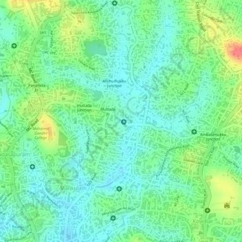
Name: Aakulam park topographic map, elevation, terrain.
Average elevation: 37 m
Minimum elevation: 15 m
Maximum elevation: 77 m
Other topographic maps
Click on a map to view its topography, its elevation and its terrain.
Akkulam Tourist Village
India > Kerala > Thiruvananthapuram
Akkulam Tourist Village, Kochuveli, Thiruvananthapuram, Kerala, 695001, India
Average elevation: 19 m
Neyyar Dam
India > Kerala > Thiruvananthapuram
Neyyar Dam, Thiruvananthapuram, Kerala, 695001, India
Average elevation: 91 m
Aruvikkara Dam
India > Kerala > Thiruvananthapuram
Aruvikkara Dam, Nedumangad, Thiruvananthapuram, Kerala, 695564, India
Average elevation: 64 m
Mannanthala
India > Kerala > Thiruvananthapuram > Mannanthala
Mannanthala, Thiruvananthapuram, Kerala, 695001, India
Average elevation: 51 m
Statue
India > Kerala > Thiruvananthapuram
Statue, Mahatma Gandhi Road, Palayam, Thampanoor, Thiruvananthapuram, Kerala, 695001, India
Average elevation: 27 m