
Thank you for supporting this site ❤️
Make a donation
Make a donation
Mbombela topographic map
Click on the map to display elevation.
Thank you for supporting this site ❤️
Make a donation
Make a donation
About this map
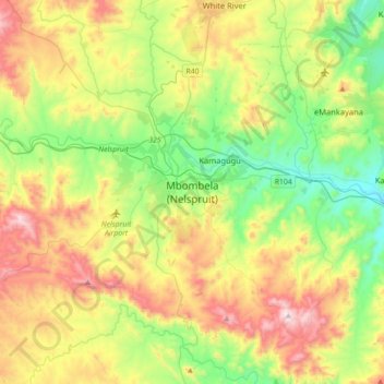
Name: Mbombela topographic map, elevation, terrain.
Average elevation: 833 m
Minimum elevation: 488 m
Maximum elevation: 1,398 m
Thank you for supporting this site ❤️
Make a donation
Make a donation
Other topographic maps
Click on a map to view its topography, its elevation and its terrain.
Mashishing
South Africa > Mpumalanga > Ehlanzeni District Municipality > Thaba Chweu Local Municipality
Average elevation: 1,421 m