
High Ridge topographic map
Interactive map
Click on the map to display elevation.
About this map
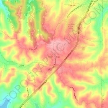
Name: High Ridge topographic map, elevation, terrain.
Average elevation: 243 m
Minimum elevation: 166 m
Maximum elevation: 291 m
High Ridge is an unincorporated community and census-designated place (CDP) in Jefferson County, Missouri, United States. The population was 4,305 at the 2010 census. At 927 feet (283 m) above sea level, High Ridge is the second-highest point in Jefferson County, second only to Sun Ridge, north of Hillsboro, according to data from the House Springs/Hillsboro 7.5 minute topographic quadrangles. The Beaumont Scout Reservation, a property of the Greater St. Louis Area Council, Boy Scouts of America, is 4 miles (6 km) north of High Ridge.
Other topographic maps
Click on a map to view its topography, its elevation and its terrain.
Marais Croche
United States of America > Missouri > Marais Croche
Marais Croche, Saint Charles County, Missouri, United States of America
Average elevation: 134 m
Platte County
United States of America > Missouri
Platte County, Missouri, United States of America
Average elevation: 276 m
Ripley County
United States of America > Missouri
Ripley County, Missouri, United States of America
Average elevation: 166 m