
Bacolor topographic map
Interactive map
Click on the map to display elevation.
About this map
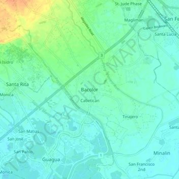
Name: Bacolor topographic map, elevation, terrain.
Location: Bacolor, Pampanga, Central Luzon, 2001, Philippines (14.95656 120.61139 15.03656 120.69139)
Average elevation: 8 m
Minimum elevation: 0 m
Maximum elevation: 34 m
Other topographic maps
Click on a map to view its topography, its elevation and its terrain.
Pigulut
Philippines > Pampanga > Lubao > San Juan
Pigulut, San Juan, Lubao, Pampanga, Central Luzon, 2004, Philippines
Average elevation: 3 m
Mount Arayat National Park
Philippines > Pampanga > Magalang > Turu
Mount Arayat National Park, Turu, Magalang, Pampanga, Central Luzon, 2011, Philippines
Average elevation: 241 m
San Isidro
Philippines > Pampanga > San Fernando
San Isidro, San Fernando, Pampanga, Central Luzon, 2000, Philippines
Average elevation: 21 m