
Thank you for supporting this site ❤️
Make a donation
Make a donation
Salla topographic map
Click on the map to display elevation.
Thank you for supporting this site ❤️
Make a donation
Make a donation
About this map
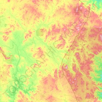
Name: Salla topographic map, elevation, terrain.
Location: Salla, Eastern Lapland, Lapland, Mainland Finland, Finland (66.40814 27.88146 67.80298 30.01706)
Average elevation: 253 m
Minimum elevation: 91 m
Maximum elevation: 620 m
Thank you for supporting this site ❤️
Make a donation
Make a donation
Other topographic maps
Click on a map to view its topography, its elevation and its terrain.
Thank you for supporting this site ❤️
Make a donation
Make a donation
Kilpisjärvi
Although Kilpisjärvi is one of the largest villages in Enontekiö, it is still quite small. In 2000 its population was recorded as 114. Like most Sami villages, Kilpisjärvi is built mainly around one major road, Käsivarrentie, or the "Arm Road" and Neljäntuulentie, or the "Four Winds' Road" — also known…
Average elevation: 527 m
Thank you for supporting this site ❤️
Make a donation
Make a donation