
Thank you for supporting this site ❤️
Make a donation
Make a donation
Chavaroux topographic map
Click on the map to display elevation.
Thank you for supporting this site ❤️
Make a donation
Make a donation
About this map
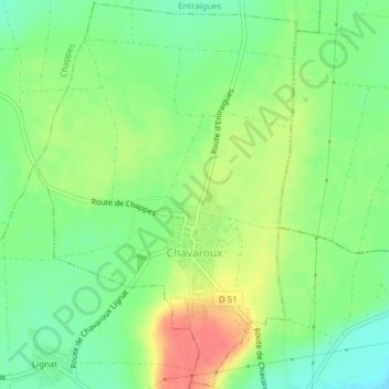
Name: Chavaroux topographic map, elevation, terrain.
Average elevation: 330 m
Minimum elevation: 305 m
Maximum elevation: 363 m
Thank you for supporting this site ❤️
Make a donation
Make a donation
Other topographic maps
Click on a map to view its topography, its elevation and its terrain.
Pôle Aqualudique
France > Auvergne-Rhône-Alpes > Puy-de-Dôme > La Bourboule > Les Vernières
Average elevation: 996 m
Thank you for supporting this site ❤️
Make a donation
Make a donation
La Ville-Tour
France > Auvergne-Rhône-Alpes > Puy-de-Dôme > Besse-et-Saint-Anastaise
Average elevation: 1,108 m
Thank you for supporting this site ❤️
Make a donation
Make a donation
Nadaillat
France > Auvergne-Rhône-Alpes > Puy-de-Dôme > Saint-Genès-Champanelle
Average elevation: 822 m
Thank you for supporting this site ❤️
Make a donation
Make a donation