
Thank you for supporting this site ❤️
Make a donation
Make a donation
Oza-Cesuras topographic map
Click on the map to display elevation.
Thank you for supporting this site ❤️
Make a donation
Make a donation
About this map
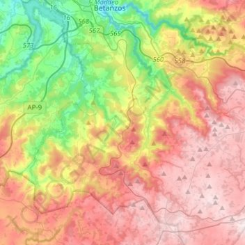
Name: Oza-Cesuras topographic map, elevation, terrain.
Location: Oza-Cesuras, Betanzos, A Coruña, Galicia, Spain (43.11927 -8.30141 43.26838 -8.05146)
Average elevation: 305 m
Minimum elevation: 2 m
Maximum elevation: 595 m
Thank you for supporting this site ❤️
Make a donation
Make a donation
Other topographic maps
Click on a map to view its topography, its elevation and its terrain.
Thank you for supporting this site ❤️
Make a donation
Make a donation
Thank you for supporting this site ❤️
Make a donation
Make a donation