
Thank you for supporting this site ❤️
Make a donation
Make a donation
Magdeburg topographic map
Click on the map to display elevation.
Thank you for supporting this site ❤️
Make a donation
Make a donation
About this map
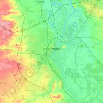
Name: Magdeburg topographic map, elevation, terrain.
Location: Magdeburg, Saxony-Anhalt, Germany (52.02375 11.51724 52.22836 11.76399)
Average elevation: 66 m
Minimum elevation: 31 m
Maximum elevation: 144 m
Thank you for supporting this site ❤️
Make a donation
Make a donation
Other topographic maps
Click on a map to view its topography, its elevation and its terrain.