
Thank you for supporting this site ❤️
Make a donation
Make a donation
Extremadura topographic map
Click on the map to display elevation.
Thank you for supporting this site ❤️
Make a donation
Make a donation
About this map
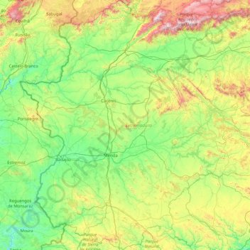
Name: Extremadura topographic map, elevation, terrain.
Location: Extremadura, Spain (37.94103 -7.54168 40.48665 -4.64758)
Average elevation: 485 m
Minimum elevation: 74 m
Maximum elevation: 2,415 m
Thank you for supporting this site ❤️
Make a donation
Make a donation
Other topographic maps
Click on a map to view its topography, its elevation and its terrain.