
Mira-Bhayander topographic map
Interactive map
Click on the map to display elevation.
About this map
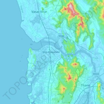
Name: Mira-Bhayander topographic map, elevation, terrain.
Location: Mira-Bhayander, Thane, Maharashtra, 401101, India (19.13629 72.70185 19.45629 73.02185)
Average elevation: 40 m
Minimum elevation: -3 m
Maximum elevation: 661 m
Other topographic maps
Click on a map to view its topography, its elevation and its terrain.
Panju Island
India > Maharashtra > Mira-Bhayander
Panju Island, Mira-Bhayander, Thane, Maharashtra, 401105, India
Average elevation: 28 m
Ulhas River
India > Maharashtra > Mira-Bhayander
Ulhas River, Mira-Bhayander, Thane, Maharashtra, 401301, India
Average elevation: 49 m