
Durg topographic map
Interactive map
Click on the map to display elevation.
About this map
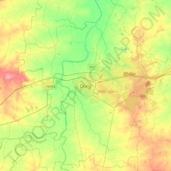
Name: Durg topographic map, elevation, terrain.
Location: Durg, Durg Tahsil, Durg District, Chhattisgarh, 491002, India (21.02965 81.12511 21.34965 81.44511)
Average elevation: 295 m
Minimum elevation: 259 m
Maximum elevation: 343 m
Other topographic maps
Click on a map to view its topography, its elevation and its terrain.
Bhilai
India > Chhattisgarh > Durg Tahsil > Bhilai
Bhilai, Durg Tahsil, Durg, Chhattisgarh, 490023, India
Average elevation: 292 m