
Thank you for supporting this site ❤️
Make a donation
Make a donation
Westonaria Local Municipality topographic map
Click on the map to display elevation.
Thank you for supporting this site ❤️
Make a donation
Make a donation
About this map
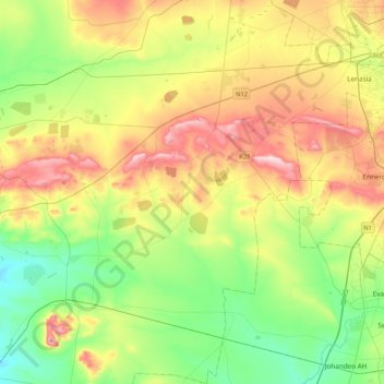
Name: Westonaria Local Municipality topographic map, elevation, terrain.
Average elevation: 1,564 m
Minimum elevation: 1,421 m
Maximum elevation: 1,798 m
Thank you for supporting this site ❤️
Make a donation
Make a donation
Other topographic maps
Click on a map to view its topography, its elevation and its terrain.
Magaliesburg
South Africa > Gauteng > West Rand District Municipality > Mogale City Local Municipality
Average elevation: 1,504 m