
Lancaster topographic map
Interactive map
Click on the map to display elevation.
About this map
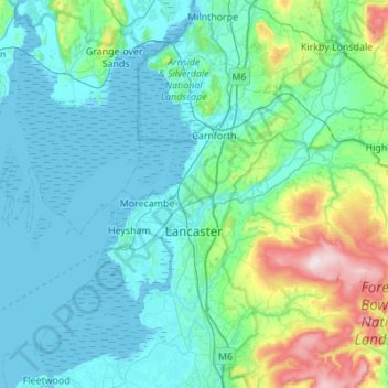
Name: Lancaster topographic map, elevation, terrain.
Location: Lancaster, Lancashire, England, United Kingdom (53.91807 -2.98365 54.23956 -2.45873)
Average elevation: 84 m
Minimum elevation: 0 m
Maximum elevation: 561 m
Other topographic maps
Click on a map to view its topography, its elevation and its terrain.
Lad Law (Boulsworth Hill)
United Kingdom > England > Lancashire > Borough of Pendle
Lad Law (Boulsworth Hill), Borough of Pendle, Lancashire, England, BB8 8ST, United Kingdom
Average elevation: 409 m
Croston
United Kingdom > England > Lancashire > Chorley
Croston, Chorley, Lancashire, England, United Kingdom
Average elevation: 8 m
Manchester
United Kingdom > England > Lancashire > Manchester
Manchester, Lancashire, North West England, England, M60 2TG, United Kingdom
Average elevation: 118 m
Preston
United Kingdom > England > Lancashire > Preston
Preston, Lancashire, North West England, England, PR2 0ZH, United Kingdom
Average elevation: 80 m
Hyndburn
United Kingdom > England > Lancashire > Hyndburn
Hyndburn, Lancashire, North West England, England, United Kingdom
Average elevation: 180 m
Padiham
United Kingdom > England > Lancashire > Padiham
Padiham, Burnley, Lancashire, North West England, England, United Kingdom
Average elevation: 104 m