
Thank you for supporting this site ❤️
Make a donation
Make a donation
King's Lynn topographic map
Click on the map to display elevation.
Thank you for supporting this site ❤️
Make a donation
Make a donation
About this map
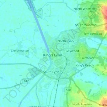
Name: King's Lynn topographic map, elevation, terrain.
Average elevation: 7 m
Minimum elevation: -2 m
Maximum elevation: 46 m
Thank you for supporting this site ❤️
Make a donation
Make a donation
Other topographic maps
Click on a map to view its topography, its elevation and its terrain.
Hockwold cum Wilton
United Kingdom > England > Norfolk > King's Lynn and West Norfolk
Average elevation: 11 m
Docking
United Kingdom > England > Norfolk > King's Lynn and West Norfolk
Docking village in the centre of the parish is situated at an elevation of 82.7 metres (272 feet), which makes it one of the highest in Norfolk. It is surrounded by arable farmland having little woodland and is a nucleated settlement, with only one historical hamlet associated with it. This is Summerfield to…
Average elevation: 63 m