
Make a donation
Saint-Cannat topographic map
Click on the map to display elevation.
Make a donation
About this map
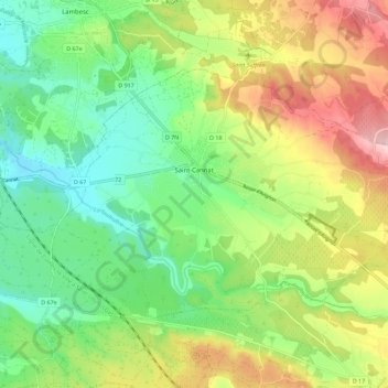
Name: Saint-Cannat topographic map, elevation, terrain.
Average elevation: 237 m
Minimum elevation: 149 m
Maximum elevation: 377 m
Make a donation
Other topographic maps
Click on a map to view its topography, its elevation and its terrain.
Mont Puget
France > Provence-Alpes-Côte d'Azur > Bouches-du-Rhône > Marseille
Average elevation: 289 m
Crête de l'Estret
France > Provence-Alpes-Côte d'Azur > Bouches-du-Rhône > Marseille
Average elevation: 307 m
Port-de-Bouc
France > Provence-Alpes-Côte d'Azur > Bouches-du-Rhône > Port-de-Bouc > Port-de-Bouc
Average elevation: 12 m
La Ciotat
France > Provence-Alpes-Côte d'Azur > Bouches-du-Rhône > La Ciotat > La Ciotat
Average elevation: 57 m
Make a donation
Harry Potter
France > Provence-Alpes-Côte d'Azur > Bouches-du-Rhône > Marseille
Average elevation: 110 m
Les Aspres
France > Provence-Alpes-Côte d'Azur > Bouches-du-Rhône > Pélissanne
Average elevation: 156 m
Lo Val de Cuech
France > Provence-Alpes-Côte d'Azur > Bouches-du-Rhône > Salon de Provence
Average elevation: 138 m
La Merindole
France > Provence-Alpes-Côte d'Azur > Bouches-du-Rhône > Aix-en-Provence
Average elevation: 140 m
Make a donation