
Make a donation
Purnia topographic map
Click on the map to display elevation.
Make a donation
About this map
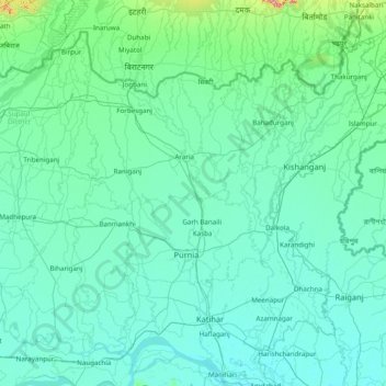
Name: Purnia topographic map, elevation, terrain.
Location: Purnia, Araria, Bihar, India (25.30000 86.80000 26.70000 88.20000)
Average elevation: 54 m
Minimum elevation: 22 m
Maximum elevation: 612 m
Make a donation
Other topographic maps
Click on a map to view its topography, its elevation and its terrain.
Make a donation
Make a donation
Make a donation
Make a donation
Make a donation
Make a donation
Make a donation
Make a donation
Make a donation
Make a donation
Make a donation
Make a donation
Make a donation
Make a donation
Make a donation
Make a donation
Make a donation
Make a donation
Make a donation
Make a donation
Make a donation
Make a donation
Make a donation
Manihari
Manihari is located at 25°21′N 87°38′E / 25.35°N 87.63°E / 25.35; 87.63. It has an average elevation of 31 m (101 feet). This place is well known for the Manihari ghat, which connects it to Sakrigali Ghaat, which is situated on the southern bank of the River Ganges.
Average elevation: 28 m
Patna
India > Bihar > Patna Rural
Patna is on the southern bank of the river Ganges. The total area of Patna is 250 km2 (97 sq mi). The municipal area constitutes 109.218 km2 (42.169 sq mi). The suburban area covers 140.782 km2 (54.356 sq mi). It has an average elevation of 53 m (174 ft). A characteristic feature of the geography of Patna is…
Average elevation: 51 m
Make a donation
Make a donation