
Thank you for supporting this site ❤️
Make a donation
Make a donation
Indio topographic map
Click on the map to display elevation.
Thank you for supporting this site ❤️
Make a donation
Make a donation
Indio
Indio is home of Riverside County's eastern administration offices. Palm Springs had more people from 1955 to 1992, when the US census announced that Indio surpassed Palm Springs and that title was returned to them. The official elevation of Indio is below sea level; the city hall is 14 feet (4 m) below sea level, as the eastern half of the Coachella Valley drops as low as 150 feet (50 m) below sea level (the lakeshore of the Salton Sea is 15 miles (24 km) south of Indio).
Thank you for supporting this site ❤️
Make a donation
Make a donation
About this map
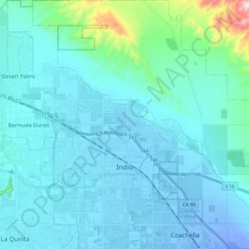
Name: Indio topographic map, elevation, terrain.
Location: Indio, Riverside County, California, United States (33.67100 -116.30127 33.81654 -116.16414)
Average elevation: 70 m
Minimum elevation: -30 m
Maximum elevation: 696 m
Thank you for supporting this site ❤️
Make a donation
Make a donation