
Cantón Atenas topographic map
Interactive map
Click on the map to display elevation.
Cantón Atenas
Atenas has an area of 127.19 km2 and a mean elevation of 706 metres.
About this map
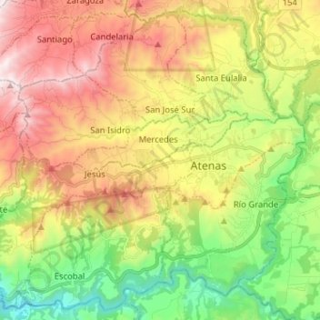
Name: Cantón Atenas topographic map, elevation, terrain.
Location: Cantón Atenas, Alajuela Province, Costa Rica (9.92030 -84.46888 10.03867 -84.34101)
Average elevation: 714 m
Minimum elevation: 143 m
Maximum elevation: 1,418 m
Other topographic maps
Click on a map to view its topography, its elevation and its terrain.
Valle Azul
Costa Rica > Alajuela Province > Cantón de San Ramón > San Lorenzo
Average elevation: 226 m
La Catarata
Costa Rica > Alajuela Province > Cantón de San Carlos > La Fortuna
Average elevation: 398 m