Guadeloupe topographic map
Interactive map
Click on the map to display elevation.
About this map
![Guadeloupe topographic map, elevation, terrain](/pub/maps/relation/tl3q/h9n3gp/thumbnail.jpg)
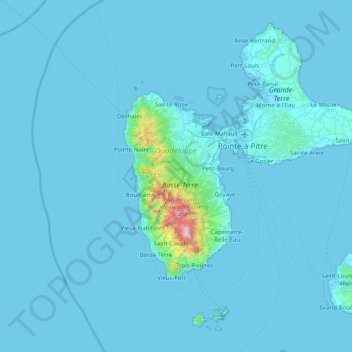
Name: Guadeloupe topographic map, elevation, terrain.
Location: Guadeloupe, France (15.83198 -61.80976 16.51448 -61.00130)
Average elevation: 37 m
Minimum elevation: -1 m
Maximum elevation: 1,442 m
The two main islands are Basse-Terre (west) and Grande-Terre (east), which form a butterfly shape as viewed from above, the two 'wings' of which are separated by the Grand Cul-de-Sac Marin, Rivière Salée [fr] and Petit Cul-de-Sac Marin. More than half of Guadeloupe's land surface consists of the 847.8 km2 Basse-Terre. The island is mountainous, containing such peaks as Mount Sans Toucher (4,442 feet; 1,354 metres) and Grande Découverte (4,143 feet; 1,263 metres), culminating in the active volcano La Grande Soufrière, the highest mountain peak in the Lesser Antilles with an elevation of 1,467 metres (4,813 ft). In contrast Grande-Terre is mostly flat, with rocky coasts to the north, irregular hills at the centre, mangrove at the southwest, and white sand beaches sheltered by coral reefs along the southern shore. This is where the main tourist resorts are found.
Other topographic maps
Click on a map to view its topography, its elevation and its terrain.
![7 topographic map, elevation, terrain](/pub/maps/node/mv51/tn64kztj/icon.jpg)
7
France > Ile-de-France > Yvelines > Poissy
7, La Bidonnière, Poissy, Saint-Germain-en-Laye, Yvelines, Ile-de-France, Metropolitan France, 78300, France
Average elevation: 109 m
![Mérignat topographic map, elevation, terrain](/pub/maps/relation/gvt6/b795k/icon.jpg)
Mérignat
France > Auvergne-Rhône-Alpes > Ain
Mérignat, Nantua, Ain, Auvergne-Rhône-Alpes, Metropolitan France, 01450, France
Average elevation: 417 m
![Manjotier topographic map, elevation, terrain](/pub/maps/node/n3l/9w84nl3l/icon.jpg)
Manjotier
France > Auvergne-Rhône-Alpes > Isère > Miribel-les-Échelles
Manjotier, Miribel-les-Échelles, Grenoble, Isère, Auvergne-Rhône-Alpes, Metropolitan France, 38380, France
Average elevation: 618 m
![Rencurel topographic map, elevation, terrain](/pub/maps/relation/f4s/mx91h/icon.jpg)
Rencurel
France > Auvergne-Rhône-Alpes > Isère
Rencurel, Grenoble, Isère, Auvergne-Rhône-Alpes, Metropolitan France, 38680, France
Average elevation: 1,099 m
![Le Grand-Lemps topographic map, elevation, terrain](/pub/maps/relation/bltf/fn6skl/icon.jpg)
Le Grand-Lemps
France > Auvergne-Rhône-Alpes > Isère
Le Grand-Lemps, La Tour-du-Pin, Isère, Auvergne-Rhône-Alpes, Metropolitan France, 38690, France
Average elevation: 512 m
![city de boutet de monvel (ethanlecartographe topographic map, elevation, terrain](/pub/maps/way/ww3l/s326kz18/icon.jpg)
city de boutet de monvel (ethanlecartographe
France > Grand Est > Meurthe-et-Moselle > Lunéville
city de boutet de monvel (ethanlecartographe, Lunéville, Meurthe-et-Moselle, Grand Est, Metropolitan France, 54300, France
Average elevation: 240 m
![Isère topographic map, elevation, terrain](/pub/maps/relation/cdnx/cdnx/icon.jpg)
Isère
Isère, Auvergne-Rhône-Alpes, Metropolitan France, France
Average elevation: 868 m
![Rambe topographic map, elevation, terrain](/pub/maps/node/13q/wcw9hr57/icon.jpg)
Rambe
France > Auvergne-Rhône-Alpes > Puy-de-Dôme > Peschadoires
Rambe, Peschadoires, Thiers, Puy-de-Dôme, Auvergne-Rhône-Alpes, Metropolitan France, 63920, France
Average elevation: 361 m
![Quéant topographic map, elevation, terrain](/pub/maps/relation/q5t6/s1d9f3/icon.jpg)
Quéant
France > Hauts-de-France > Pas-de-Calais
Quéant, Arras, Pas-de-Calais, Hauts-de-France, Metropolitan France, 62860, France
Average elevation: 85 m
![Le Born topographic map, elevation, terrain](/pub/maps/relation/hntj/84x39m/icon.jpg)
Le Born
France > Occitania > Haute-Garonne
Le Born, Toulouse, Haute-Garonne, Occitania, Metropolitan France, 31340, France
Average elevation: 169 m
![Fontaine topographic map, elevation, terrain](/pub/maps/relation/3818/6tfkl/icon.jpg)
Fontaine
France > Auvergne-Rhône-Alpes > Isère
Fontaine, Grenoble, Isère, Auvergne-Rhône-Alpes, Metropolitan France, 38600, France
Average elevation: 253 m
![Noreuil topographic map, elevation, terrain](/pub/maps/relation/fp18/db123l/icon.jpg)
Noreuil
France > Hauts-de-France > Pas-de-Calais
Noreuil, Arras, Pas-de-Calais, Hauts-de-France, Metropolitan France, 62128, France
Average elevation: 97 m
![Montagnole topographic map, elevation, terrain](/pub/maps/relation/dr14/fxrs8/icon.jpg)
Montagnole
France > Auvergne-Rhône-Alpes > Savoy
Montagnole, Chambéry, Savoy, Auvergne-Rhône-Alpes, Metropolitan France, 73000, France
Average elevation: 685 m
![Mézos topographic map, elevation, terrain](/pub/maps/relation/t3m2/bx95k/icon.jpg)
Mézos
France > Nouvelle-Aquitaine > Landes
Mézos, Mont-de-Marsan, Landes, Nouvelle-Aquitaine, Metropolitan France, 40170, France
Average elevation: 40 m
![Village Tumukuru topographic map, elevation, terrain](/pub/maps/node/lhb3/zml6sjt6/icon.jpg)
Village Tumukuru
France > French Polynesia > Tatakoto
Village Tumukuru, Tatakoto, Tuamotu-Gambier, French Polynesia, 98783, France
Average elevation: 1 m
![Champniers topographic map, elevation, terrain](/pub/maps/relation/dxzs/mrftp/icon.jpg)
Champniers
France > Nouvelle-Aquitaine > Charente
Champniers, Angoulême, Charente, Nouvelle-Aquitaine, Metropolitan France, 16430, France
Average elevation: 92 m
![Montferrand topographic map, elevation, terrain](/pub/maps/relation/df3/k4tf57/icon.jpg)
Montferrand
Montferrand, Carcassonne, Aude, Occitania, Metropolitan France, 11320, France
Average elevation: 222 m
![Ain topographic map, elevation, terrain](/pub/maps/relation/kv18/kv18/icon.jpg)
Ain
Ain, Auvergne-Rhône-Alpes, Metropolitan France, France
Average elevation: 418 m
![Rangiroa topographic map, elevation, terrain](/pub/maps/relation/8xnh/9zc6b3/icon.jpg)
Rangiroa
France > French Polynesia > Rangiroa
Rangiroa, Tuamotu-Gambier, French Polynesia, 98775, France
Average elevation: 0 m
![Maine-et-Loire topographic map, elevation, terrain](/pub/maps/relation/tx3q/tx3q/icon.jpg)
Maine-et-Loire
Maine-et-Loire, Pays de la Loire, Metropolitan France, France
Average elevation: 76 m
![Custines topographic map, elevation, terrain](/pub/maps/relation/45mt/wp257/icon.jpg)
Custines
France > Grand Est > Meurthe-et-Moselle
Custines, Nancy, Meurthe-et-Moselle, Grand Est, Metropolitan France, 54670, France
Average elevation: 275 m
![Sus topographic map, elevation, terrain](/pub/maps/relation/krzs/svzf18/icon.jpg)
Sus
France > Nouvelle-Aquitaine > Pyrénées-Atlantiques
Sus, Oloron-Sainte-Marie, Pyrénées-Atlantiques, Nouvelle-Aquitaine, Metropolitan France, 64190, France
Average elevation: 162 m
![Domaine de Saint-Lambert topographic map, elevation, terrain](/pub/maps/way/sc51/bv45nnx/icon.jpg)
Domaine de Saint-Lambert
France > Occitania > Lozère > Marvejols
Domaine de Saint-Lambert, Promenade Louis Cabanettes, Marvejols, Mende, Lozère, Occitania, Metropolitan France, 48100, France
Average elevation: 725 m
![Pregnin topographic map, elevation, terrain](/pub/maps/node/t2rr/8fvmj6nh/icon.jpg)
Pregnin
France > Auvergne-Rhône-Alpes > Ain > Saint-Genis-Pouilly
Pregnin, Saint-Genis-Pouilly, Gex, Ain, Auvergne-Rhône-Alpes, Metropolitan France, 01630, France
Average elevation: 473 m
![Juan de Nova Island topographic map, elevation, terrain](/pub/maps/relation/dftp/nl2gtj/icon.jpg)
Juan de Nova Island
France > French Southern and Antarctic Lands
Juan de Nova Island, Scattered Islands in the Indian Ocean, French Southern and Antarctic Lands, France
Average elevation: 0 m
![Saint-Pierre-de-Cernières topographic map, elevation, terrain](/pub/maps/relation/tq51/lrcw9m/icon.jpg)
Saint-Pierre-de-Cernières
Saint-Pierre-de-Cernières, Bernay, Eure, Normandy, Metropolitan France, 27390, France
Average elevation: 201 m
![Le Not topographic map, elevation, terrain](/pub/maps/node/fj1h/mbj6cl14/icon.jpg)
Le Not
France > Auvergne-Rhône-Alpes > Isère > Saint-Hilaire-de-la-Côte
Le Not, Saint-Hilaire-de-la-Côte, Vienne, Isère, Auvergne-Rhône-Alpes, Metropolitan France, 38260, France
Average elevation: 406 m
![Entrange Cité topographic map, elevation, terrain](/pub/maps/node/xxkl/6plfh64s/icon.jpg)
Entrange Cité
Entrange Cité, Entrange, Thionville, Moselle, Grand Est, Metropolitan France, 57330, France
Average elevation: 237 m
![Saint-Nazaire topographic map, elevation, terrain](/pub/maps/relation/vqm2/xq8kl/icon.jpg)
Saint-Nazaire
France > Pays de la Loire > Loire-Atlantique
Saint-Nazaire, Loire-Atlantique, Pays de la Loire, Metropolitan France, 44600, France
Average elevation: 6 m
![Cachar topographic map, elevation, terrain](/pub/maps/node/s218/lzvzqz14/icon.jpg)
Cachar
France > Occitania > Gard > Saint-Jean-du-Gard
Cachar, Saint-Jean-du-Gard, Alès, Gard, Occitania, Metropolitan France, 30270, France
Average elevation: 312 m
![Mandrel topographic map, elevation, terrain](/pub/maps/node/zztj/6g745314/icon.jpg)
Mandrel
France > Grand Est > Aube > Lignol-le-Château
Mandrel, Lignol-le-Château, Bar-sur-Aube, Aube, Grand Est, Metropolitan France, 10200, France
Average elevation: 262 m
![Sénestis topographic map, elevation, terrain](/pub/maps/relation/1tcz/m5pmt/icon.jpg)
Sénestis
France > Nouvelle-Aquitaine > Lot-et-Garonne
Sénestis, Marmande, Lot-et-Garonne, Nouvelle-Aquitaine, Metropolitan France, 47430, France
Average elevation: 32 m