
La Réunion topographic map
Interactive map
Click on the map to display elevation.
About this map
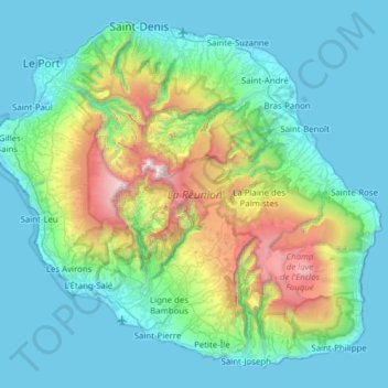
Name: La Réunion topographic map, elevation, terrain.
Location: La Réunion, Saint-Benoît, Réunion, France (-21.38973 55.21643 -20.87174 55.83669)
Average elevation: 532 m
Minimum elevation: 0 m
Maximum elevation: 3,055 m
Other topographic maps
Click on a map to view its topography, its elevation and its terrain.
Takamaka
France > Réunion > Saint-Benoît
Takamaka, Chemin Grand Fond, Saint-Benoît, Réunion, 97431, France
Average elevation: 851 m