
Granada topographic map
Click on the map to display elevation.
Granada
Granada (/ɡrəˈnɑːdə/ grə-NAH-də; Spanish: [ɡɾaˈnaða] ) is the capital city of the province of Granada, in the autonomous community of Andalusia, Spain. Granada is located at the foot of the Sierra Nevada mountains, at the confluence of four rivers, the Darro, the Genil, the Monachil and the Beiro. Ascribed to the Vega de Granada comarca, the city sits at an average elevation of 738 m (2,421 ft) above sea level, yet is only one hour by car from the Mediterranean coast, the Costa Tropical. With a population of 233,532 as of 2024, it is the 20th-largest city in Spain.
About this map
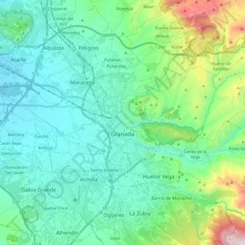
Name: Granada topographic map, elevation, terrain.
Average elevation: 829 m
Minimum elevation: 577 m
Maximum elevation: 1,828 m
Other topographic maps
Click on a map to view its topography, its elevation and its terrain.
Jardines del Triunfo
Spain > Andalusia > Comarca de la Vega de Granada > Granada
Average elevation: 719 m
Cortijo del Aire
Spain > Andalusia > Comarca de la Vega de Granada > Albolote
Average elevation: 706 m