
Sergipe topographic map
Interactive map
Click on the map to display elevation.
About this map
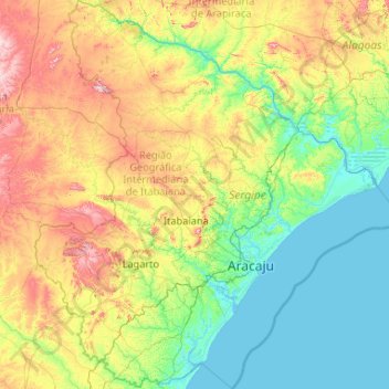
Name: Sergipe topographic map, elevation, terrain.
Location: Sergipe, Northeast Region, Brazil (-11.56853 -38.24500 -9.51500 -36.28197)
Average elevation: 160 m
Minimum elevation: -2 m
Maximum elevation: 710 m
Other topographic maps
Click on a map to view its topography, its elevation and its terrain.