
Make a donation
Worthing topographic map
Click on the map to display elevation.
Make a donation
About this map
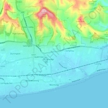
Name: Worthing topographic map, elevation, terrain.
Location: Worthing, West Sussex, England, United Kingdom (50.80174 -0.44656 50.86326 -0.33026)
Average elevation: 35 m
Minimum elevation: -2 m
Maximum elevation: 183 m
Make a donation
Other topographic maps
Click on a map to view its topography, its elevation and its terrain.
Ardingly Reservoir
United Kingdom > England > West Sussex > Mid Sussex > Ardingly
Average elevation: 98 m
Make a donation
Make a donation
Gay Street
United Kingdom > England > West Sussex > Horsham > West Chiltington
Average elevation: 38 m
Make a donation
Washington Common
United Kingdom > England > West Sussex > Storrington > Washington
Average elevation: 61 m
Make a donation
Felbridge
United Kingdom > England > West Sussex > Mid Sussex > East Grinstead
Average elevation: 98 m
Make a donation
Make a donation
Make a donation
Henry Burt Wood
United Kingdom > England > West Sussex > Mid Sussex > Burgess Hill
Average elevation: 39 m
Make a donation
Make a donation
Sullington Warren
United Kingdom > England > West Sussex > Horsham > Storrington
Average elevation: 54 m
Make a donation
Make a donation
Worth Abbey
United Kingdom > England > West Sussex > Mid Sussex > Turners Hill
Average elevation: 124 m
Make a donation
Make a donation
Make a donation
Make a donation
Make a donation
Make a donation
Make a donation
Make a donation
Make a donation
Make a donation
Make a donation
Make a donation
Make a donation
Smock Alley
United Kingdom > England > West Sussex > Horsham > West Chiltington Common
Average elevation: 38 m
Twineham Green
United Kingdom > England > West Sussex > Mid Sussex > Hickstead > Twineham Green
Average elevation: 21 m
Make a donation