
Make a donation
Douglas topographic map
Click on the map to display elevation.
Make a donation
Douglas
The principal elevations are Bald Hill, 711 feet (217 m), Wallum Pond Hill, 778 feet (237 m), Mount Ashworth, 713 feet (218 m), and Mount Daniel, 735 feet (224 m). There are numerous ponds in Douglas: Wallum Pond in the southwestern section, covering approximately 150 acres (61 ha); Badluck Pond in the western part of town, covering about 110 acres (45 ha); the largest pond is Whitin Reservoir, also in the western part of town, covering about 400 acres (160 ha); and Manchaug Pond in the northern part, about 93 acres (38 ha).
Make a donation
About this map
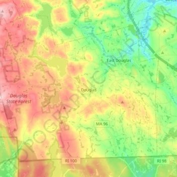
Name: Douglas topographic map, elevation, terrain.
Average elevation: 173 m
Minimum elevation: 87 m
Maximum elevation: 273 m
Make a donation
Other topographic maps
Click on a map to view its topography, its elevation and its terrain.