
Córdoba topographic map
Interactive map
Click on the map to display elevation.
Córdoba
The differences in elevation in the Valley are very small, ranging from 100 and 170 metres above sea level, with the city proper located at an average altitude of roughly 125 metres above sea level. The landscape of the valley is further subdivided in the piedmont connecting with the Sierra, the fluvial terraces and the most immediate vicinity of the river course.
About this map
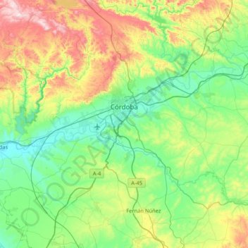
Name: Córdoba topographic map, elevation, terrain.
Location: Córdoba, Andalusia, Spain (37.66582 -4.99860 38.03152 -4.35143)
Average elevation: 281 m
Minimum elevation: 64 m
Maximum elevation: 878 m
Other topographic maps
Click on a map to view its topography, its elevation and its terrain.
Cádiz
The Baluarte de la Candelaria (fortress or stronghold of Candlemas) is a military fortification. Taking advantage of a natural elevation of land, it was constructed in 1672 at the initiative of the governor, Diego Caballero de Illescas. Protected by a seaward-facing wall that had previously served as a…
Average elevation: 3 m