
Thank you for supporting this site ❤️
Make a donation
Make a donation
Mafraq topographic map
Click on the map to display elevation.
Thank you for supporting this site ❤️
Make a donation
Make a donation
About this map
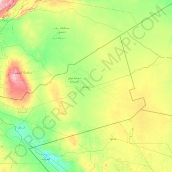
Name: Mafraq topographic map, elevation, terrain.
Location: Mafraq, Jordan (31.70309 35.92524 33.37344 39.29986)
Average elevation: 765 m
Minimum elevation: 487 m
Maximum elevation: 1,995 m
Thank you for supporting this site ❤️
Make a donation
Make a donation
Other topographic maps
Click on a map to view its topography, its elevation and its terrain.
Thank you for supporting this site ❤️
Make a donation
Make a donation
Thank you for supporting this site ❤️
Make a donation
Make a donation
Zarqa
Jordan > Zarqa > Zarqa Sub-District
Zarqa has a cold semi-arid climate (Köppen climate classification: BSk). The average annual temperature is 17.4 °C (63.3 °F), and around 182 mm (7.17 in) of precipitation falls annually, mostly in winter months. Zarqa's elevation is 619 meters above sea level, and the city occasionally receives snowfall in…
Average elevation: 617 m
Thank you for supporting this site ❤️
Make a donation
Make a donation