
Yen Bai City topographic map
Interactive map
Click on the map to display elevation.
Yen Bai City
The topography is steep, rising from east to west and from south to north. The average elevation is about 600 metres (2,000 ft) above sea level and can be divided into two regions: low-lying regions on the left bank of the Red River basin and the high right bank of the Red River and in the plateau between the Red River and Đà River there are many mountains. Besides the two main rivers, the Red and the Đà, the province has about 200 canals, small streams and large lakes and swamps. Thác Bà Lake is situated in the province, an artificial lake which has an area of 23,400 hectares (90 sq mi) and 1,331 islands and hills. It has a capacity of 3 to 3.9 billion cubic meters of water and its original intention was to run the Thác Bà hydroelectric plant, one of the first large hydropower projects in Vietnam. The water in the lake is blue and clear, and reflects the surrounding green forests. The thousands of hills and islands have many caves, including Hum, Cau Cuoi and Bach Xa. A Thác Bà Temple is located in the lake area. Thác Bà Lake has changed the climatic pattern in the western districts of the province, to a moderate condition from its hot and dry status.
About this map
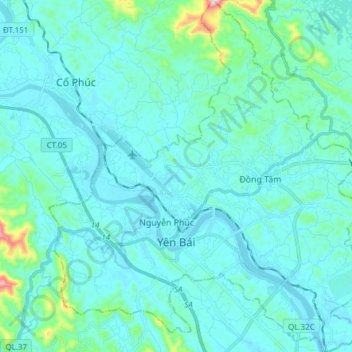
Name: Yen Bai City topographic map, elevation, terrain.
Location: Yen Bai City, Yen Bai Province, Vietnam (21.65190 104.82036 21.79281 104.95498)
Average elevation: 72 m
Minimum elevation: 25 m
Maximum elevation: 471 m