
Thank you for supporting this site ❤️
Make a donation
Make a donation
Dubrovnik topographic map
Click on the map to display elevation.
Thank you for supporting this site ❤️
Make a donation
Make a donation
Dubrovnik
Since records began in 1961, the highest temperature recorded at the local weather station at an elevation of 52 metres (171 ft) was 38.9 °C (102.0 °F), on 13 August 2025. The coldest temperature was −7.0 °C (19.4 °F), on 14 January 1968.
Thank you for supporting this site ❤️
Make a donation
Make a donation
About this map
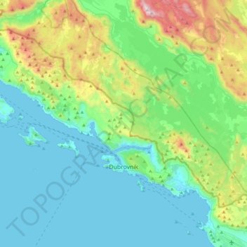
Name: Dubrovnik topographic map, elevation, terrain.
Location: Dubrovnik, Dubrovnik-Neretva County, Croatia (42.62089 17.76559 42.78036 18.15811)
Average elevation: 297 m
Minimum elevation: -2 m
Maximum elevation: 1,386 m
Thank you for supporting this site ❤️
Make a donation
Make a donation
Other topographic maps
Click on a map to view its topography, its elevation and its terrain.
Thank you for supporting this site ❤️
Make a donation
Make a donation
Thank you for supporting this site ❤️
Make a donation
Make a donation
Thank you for supporting this site ❤️
Make a donation
Make a donation
Thank you for supporting this site ❤️
Make a donation
Make a donation
Thank you for supporting this site ❤️
Make a donation
Make a donation
Thank you for supporting this site ❤️
Make a donation
Make a donation