
Pará topographic map
Interactive map
Click on the map to display elevation.
About this map
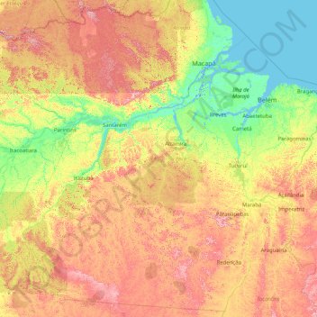
Name: Pará topographic map, elevation, terrain.
Location: Pará, North Region, Brazil (-9.83902 -58.89700 2.59093 -45.94379)
Average elevation: 174 m
Minimum elevation: -4 m
Maximum elevation: 921 m
Other topographic maps
Click on a map to view its topography, its elevation and its terrain.
Picado
Brazil > Bahia > Região Metropolitana de Feira de Santana > Conceição do Jacuípe
Average elevation: 188 m
Jardim São Lourenço
Brazil > São Paulo > Região Metropolitana de São Paulo > São Paulo
Average elevation: 790 m
Juami River
Juami River is a black water river, a tributary of the white water Japurá River, and runs through the Amazon plain. The entire basin of the Juami River is contained within the Juami-Japurá Ecological Station. The basin has altitudes that range from 45 to 450 metres (148 to 1,476 ft) above sea level.
Average elevation: 109 m
São Paulo
Brazil > São Paulo > Região Metropolitana de São Paulo > São Paulo
São Paulo is in Southeastern Brazil, in southeastern São Paulo State, approximately halfway between Curitiba and Rio de Janeiro. The city is on a plateau placed beyond the Serra do Mar (Portuguese for "Sea Range" or "Coastal Range"), itself a component of the vast region known as the Brazilian Highlands,…
Average elevation: 785 m
Porto Alegre
Brazil > Rio Grande do Sul > Metropolitan Region of Porto Alegre > Porto Alegre
Porto Alegre has a long coastline on the Guaíba Lake, and its topography is punctuated by 40 hills. In the lake, a vast body of water, a maze of islands facing the city creates an archipelago where a unique ecosystem gives shelter to abundant wildlife. The city area concentrates 28% of the native flora of Rio…
Average elevation: 27 m
Santo Ignácio
Brazil > Rio de Janeiro > Região Metropolitana do Rio de Janeiro > Niterói
Average elevation: 114 m
Fazenda Vargem Grande
Brazil > Bahia > Bom Jesus da Lapa > Fazenda Vargem Grande
Average elevation: 427 m
Formosa
Brazil > Goiás > Região Integrada de Desenvolvimento do Distrito Federal e Entorno > Formosa
Average elevation: 921 m
Belo Horizonte
Brazil > Minas Gerais > Região Metropolitana de Belo Horizonte > Belo Horizonte
In 1893, due to the climatic and topographic conditions, Curral Del Rey was selected by Minas Gerais governor Afonso Pena among other cities as the location for the new economic and cultural center of the state, under the new name of Cidade de Minas, or City of Minas.
Average elevation: 904 m
Praça Columia City/ Bom Fim
Brazil > Rio Grande do Sul > Metropolitan Region of Porto Alegre > Guaíba
Average elevation: 26 m