
Provo topographic map
Click on the map to display elevation.
Provo
Provo lies on the eastern bank of Utah Lake in Utah Valley at an elevation of 4,549 feet (1,387 m). According to the United States Census Bureau, the city has an area of 44.2 square miles (114.4 km2), of which 41.7 square miles (107.9 km2) is land and 2.5 square miles (6.5 km2), or 5.66%, is water.
About this map
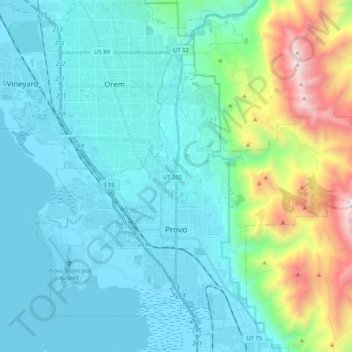
Name: Provo topographic map, elevation, terrain.
Location: Provo, Utah County, Utah, United States (40.18580 -111.74096 40.32880 -111.53687)
Average elevation: 1,728 m
Minimum elevation: 1,364 m
Maximum elevation: 3,356 m
Other topographic maps
Click on a map to view its topography, its elevation and its terrain.