
Thank you for supporting this site ❤️
Make a donation
Make a donation
Godalming topographic map
Click on the map to display elevation.
Thank you for supporting this site ❤️
Make a donation
Make a donation
About this map
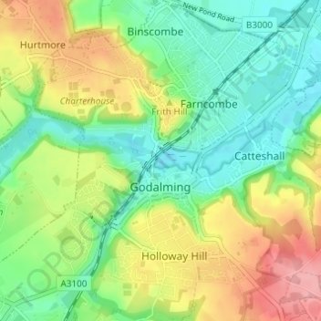
Name: Godalming topographic map, elevation, terrain.
Location: Godalming, Waverley, Surrey, England, United Kingdom (51.16986 -0.64093 51.20806 -0.58489)
Average elevation: 71 m
Minimum elevation: 31 m
Maximum elevation: 133 m
Thank you for supporting this site ❤️
Make a donation
Make a donation
Other topographic maps
Click on a map to view its topography, its elevation and its terrain.
Thank you for supporting this site ❤️
Make a donation
Make a donation
Thank you for supporting this site ❤️
Make a donation
Make a donation
Hankley Common
United Kingdom > England > Surrey > Waverley > Thursley > Truxford
Average elevation: 70 m
Thank you for supporting this site ❤️
Make a donation
Make a donation
Thank you for supporting this site ❤️
Make a donation
Make a donation
Camelsdale
United Kingdom > England > Surrey > Waverley > Haslemere > Shottermill
Average elevation: 166 m
Thank you for supporting this site ❤️
Make a donation
Make a donation
Thank you for supporting this site ❤️
Make a donation
Make a donation
Thank you for supporting this site ❤️
Make a donation
Make a donation
Floodplain (seasonal)
United Kingdom > England > Surrey > Waverley > Farnham > Wrecclesham
Average elevation: 94 m
Thank you for supporting this site ❤️
Make a donation
Make a donation