
Thank you for supporting this site ❤️
Make a donation
Make a donation
Kuala Selangor topographic map
Click on the map to display elevation.
Thank you for supporting this site ❤️
Make a donation
Make a donation
About this map
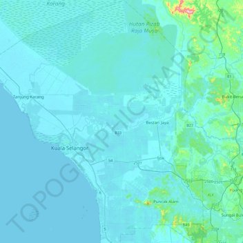
Name: Kuala Selangor topographic map, elevation, terrain.
Location: Kuala Selangor, Selangor, Malaysia (3.15911 101.10081 3.59889 101.49383)
Average elevation: 18 m
Minimum elevation: -1 m
Maximum elevation: 337 m
Thank you for supporting this site ❤️
Make a donation
Make a donation
Other topographic maps
Click on a map to view its topography, its elevation and its terrain.