
Thank you for supporting this site ❤️
Make a donation
Make a donation
Sundargarh topographic map
Click on the map to display elevation.
Thank you for supporting this site ❤️
Make a donation
Make a donation
Sundargarh
Sundargarh is located at 22°07′N 84°02′E / 22.12°N 84.03°E / 22.12; 84.03. It has an average elevation of 243 metres (801 feet). The Ib river flows along in the north.
Thank you for supporting this site ❤️
Make a donation
Make a donation
About this map
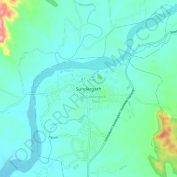
Name: Sundargarh topographic map, elevation, terrain.
Location: Sundargarh, Sundargarh Town, Sundargarh, Odisha, 770001, India (22.07997 83.99699 22.15997 84.07699)
Average elevation: 244 m
Minimum elevation: 214 m
Maximum elevation: 400 m
Thank you for supporting this site ❤️
Make a donation
Make a donation