
Make a donation
Houaphanh topographic map
Click on the map to display elevation.
Make a donation
Houaphanh
The Nam Neun IBA area of Nam Et is adjacent to the NBCA. Nam Neun is 85,450 ha in size, and is at an elevation of 800–1,500 metres (2,600–4,900 ft). The habitat is characterized as mixed deciduous forest, as well as dry evergreen forest, with stands of bamboo, and occasional conifers; cleared areas have been replaced by areas of secondary grassland. Key avifauna include great hornbill (Buceros bicornis) and Blyth's kingfisher (Alcedo hercules).
Make a donation
About this map
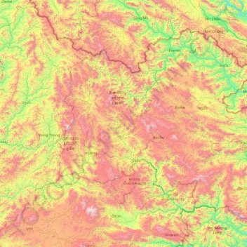
Name: Houaphanh topographic map, elevation, terrain.
Location: Houaphanh, Laos (19.61020 103.10735 20.97656 104.99377)
Average elevation: 963 m
Minimum elevation: 110 m
Maximum elevation: 2,216 m
Make a donation
Other topographic maps
Click on a map to view its topography, its elevation and its terrain.
Sengsavang
Laos > Vientiane Prefecture > Xaysetha District > Vientiane Capital
Average elevation: 171 m
Make a donation
B. Phonthongchommani
Laos > Vientiane Prefecture > Chanthabuly District > Vientiane Capital
Average elevation: 173 m
Make a donation
B. Phonsavang
Laos > Vientiane Prefecture > Chanthabuly District > Vientiane Capital
Average elevation: 174 m
Phonpapao
Laos > Vientiane Prefecture > Sisattanak District > Vientiane Capital
Average elevation: 170 m
Make a donation
Hatsadi
Laos > Vientiane Prefecture > Chanthabuly District > Vientiane Capital
Average elevation: 170 m
Make a donation