
Mińsk County topographic map
Interactive map
Click on the map to display elevation.
About this map
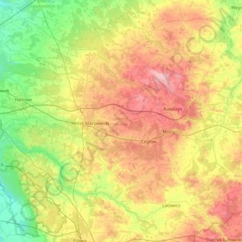
Name: Mińsk County topographic map, elevation, terrain.
Location: Mińsk County, Masovian Voivodeship, Poland (51.97357 21.23795 52.39501 21.97992)
Average elevation: 143 m
Minimum elevation: 87 m
Maximum elevation: 225 m
Other topographic maps
Click on a map to view its topography, its elevation and its terrain.
Warsaw
Poland > Masovian Voivodeship > Warsaw > Warsaw
Warsaw lies in east-central Poland about 300 km (190 mi) from the Carpathian Mountains and about 260 km (160 mi) from the Baltic Sea, 523 km (325 mi) east of Berlin, Germany. The city straddles the Vistula River. It is located in the heartland of the Masovian Plain, and its average elevation is 100 m (330 ft)…
Average elevation: 95 m