
Amiens topographic map
Interactive map
Click on the map to display elevation.
About this map
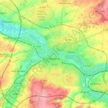
Name: Amiens topographic map, elevation, terrain.
Location: Amiens, Somme, Hauts-de-France, Metropolitan France, France (49.84684 2.22356 49.95055 2.34578)
Average elevation: 55 m
Minimum elevation: 9 m
Maximum elevation: 116 m
The area of the commune is 4,946 hectares (12,220 acres); the altitude varies between 14 and 106 metres (46 and 348 ft).
Other topographic maps
Click on a map to view its topography, its elevation and its terrain.
Amiens
France > Hauts-de-France > Somme > Amiens
Amiens, Somme, Hauts-de-France, Metropolitan France, 80000, France
Average elevation: 86 m
Saleux
France > Hauts-de-France > Somme > Saleux
Saleux, Amiens, Somme, Hauts-de-France, Metropolitan France, 80480, France
Average elevation: 67 m