
Thank you for supporting this site ❤️
Make a donation
Make a donation
Bardhaman topographic map
Click on the map to display elevation.
Thank you for supporting this site ❤️
Make a donation
Make a donation
Bardhaman
The region has an average elevation of 40 metres (131 ft). The city is situated 1100 km from New Delhi and a little less than 100 km north-west of Kolkata on the Grand Trunk Road (National Highway 19) and Eastern Railway. The chief rivers are the Damodar and the Banka.
Thank you for supporting this site ❤️
Make a donation
Make a donation
About this map
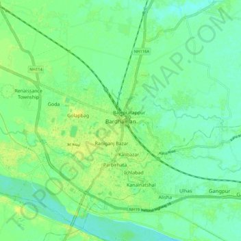
Name: Bardhaman topographic map, elevation, terrain.
Location: Bardhaman, Burdwan - I, Purba Bardhaman, West Bengal, India (23.20900 87.82010 23.29048 87.92412)
Average elevation: 31 m
Minimum elevation: 23 m
Maximum elevation: 40 m
Thank you for supporting this site ❤️
Make a donation
Make a donation