
Make a donation
Mühlheim topographic map
Click on the map to display elevation.
Make a donation
Mühlheim
Die Stadt liegt zwischen Schwarzwald und Schwäbischer Alb rund 60 Kilometer südwestlich von Stuttgart auf einer Höhe von 410 bis 675 m ü. NHN. Sulz hat mit einer Größe von 87,60 km² das größte Gemeindegebiet im Landkreis Rottweil.
Make a donation
About this map
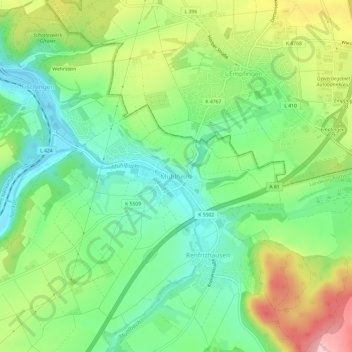
Name: Mühlheim topographic map, elevation, terrain.
Average elevation: 489 m
Minimum elevation: 411 m
Maximum elevation: 621 m
Make a donation
Other topographic maps
Click on a map to view its topography, its elevation and its terrain.
Dürrenmettstetten
Deutschland > Baden-Württemberg > Landkreis Rottweil > Sulz am Neckar
Average elevation: 627 m
Bergfelden
Deutschland > Baden-Württemberg > Landkreis Rottweil > Sulz am Neckar
Bergfelden liegt knapp fünf Kilometer östlich der Stadt Sulz am Neckar, im oberen Mühlbachtal am Fuße des Dickebergs. Der Ort liegt auf einer Höhe von 490 m ü. NN und hat ca. 1700 Einwohner (Stand 2015).
Average elevation: 528 m
Holzhausen
Deutschland > Baden-Württemberg > Landkreis Rottweil > Sulz am Neckar
Average elevation: 501 m
Make a donation