
Daulatabad topographic map
Interactive map
Click on the map to display elevation.
About this map
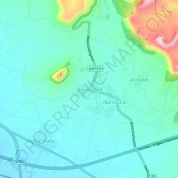
Name: Daulatabad topographic map, elevation, terrain.
Location: Daulatabad, Chhatrapati Sambhajinagar, Maharashtra, India (19.91916 75.19960 19.95916 75.23960)
Average elevation: 618 m
Minimum elevation: 563 m
Maximum elevation: 850 m
Other topographic maps
Click on a map to view its topography, its elevation and its terrain.
Chhatrapati Sambhajinagar
India > Maharashtra > Chhatrapati Sambhajinagar
Chhatrapati Sambhajinagar, Maharashtra, 431002, India
Average elevation: 618 m
Abdimandi
India > Maharashtra > Chhatrapati Sambhajinagar
Abdimandi, Chhatrapati Sambhajinagar, Maharashtra, India
Average elevation: 627 m
Devagiri Fort
India > Maharashtra > Chhatrapati Sambhajinagar > Daulatabad
Devagiri Fort, Beed Chalisgaon, Daulatabad, Chhatrapati Sambhajinagar, Maharashtra, India
Average elevation: 606 m
Shendra
India > Maharashtra > Chhatrapati Sambhajinagar
Shendra, Chhatrapati Sambhajinagar, Maharashtra, 431201, India
Average elevation: 583 m