
Botolan topographic map
Interactive map
Click on the map to display elevation.
About this map
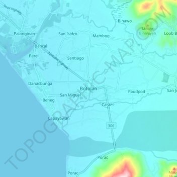
Name: Botolan topographic map, elevation, terrain.
Location: Botolan, Zambales, Central Luzon, 2202, Philippines (15.24900 119.98474 15.32900 120.06474)
Average elevation: 22 m
Minimum elevation: -1 m
Maximum elevation: 323 m
Other topographic maps
Click on a map to view its topography, its elevation and its terrain.
Mapanuepe Lake
Philippines > Zambales > Aglao
Mapanuepe Lake, Aglao, Zambales, Central Luzon, Philippines
Average elevation: 188 m
Capones Island
Capones Island, Zambales, Central Luzon, Philippines
Average elevation: 1 m