
Thank you for supporting this site ❤️
Make a donation
Make a donation
Llano County topographic map
Click on the map to display elevation.
Thank you for supporting this site ❤️
Make a donation
Make a donation
About this map
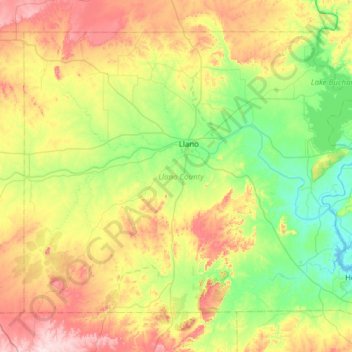
Name: Llano County topographic map, elevation, terrain.
Location: Llano County, Texas, United States (30.48610 -98.96456 30.92187 -98.35104)
Average elevation: 395 m
Minimum elevation: 251 m
Maximum elevation: 656 m
Thank you for supporting this site ❤️
Make a donation
Make a donation
Other topographic maps
Click on a map to view its topography, its elevation and its terrain.
Enchanted Rock
United States > Texas > Llano County
Enchanted Rock is a pink granite mountain located in the Llano Uplift about 17 miles (27 km) north of Fredericksburg, Texas and 24 miles (39 km) south of Llano, Texas, United States. Enchanted Rock State Natural Area, which includes Enchanted Rock and surrounding land, spans the border between Gillespie and…
Average elevation: 453 m